Thursday, December 29, 2011

Fun in the sun! (not really)

Today it was raining all day.  We really wanted to go riding- regardless of the weather.  We headed out about 1:30 and headed for Panther Gulch.  1 hr 40 minute ride and we rode 15 miles, nearly 2000 feet vertical.


View Larger Map
The rain really starting coming down for the Findley downhill.  It was a mudbath...  Here is a pic of us after the ride.  We should have waited to wash the bikes off till after the picture was taken. 


Monday, December 26, 2011

Findley Peak

My new Christmas present- a Garmin Edge 500.  Took it up Findley Peak:


You can download the KML file and import into google maps.  Here, I embeded a google earth view of the route.

View Larger Map

Thursday, December 22, 2011

Back to 30 minutes

Headed out on the bike this morning and it was very cold. I waited until about 10:00, hoping it would warm up a bit. The sun was out and it was a beautiful day, but it was still very cold. It has been difficult for me lately to get up Findley ridge in 30 minutes (my best time yet). Today I was hoping for a good time and I was able to keep a good pace most of the way up. Regardless of the cold temp I had to put my jacket in the backpack for the climb. It took 30 minutes to get the ridge from the bottom of the road- junction of williams hwy and Findley road. I'm confident by the end of the break I'll be able to get up to the top of the ridge in less than 30 minutes.

Tuesday, December 20, 2011

Layton Ditch Trail- 1000 miles turned over today

I turned over 1000 miles on my new bike today.  I've had it since early February.  There has been a lot of great miles on it.  I'm looking forward to the next 1000. 

Marty and I took off from his place up Panther Gulch on a sunny but cold morning.  We rode up Panther gulch to the Layton Ditch Mine Trail and took that until it turns into a logging road.  Here are a few pictures from the trail.  There are a few sections of what I'd call a Manzanita cave. 

 There also some nice sections of large trees with lots of canopy cover.  It was a lot colder in these sections with all the shade.
Look close you can see Marty...


We explored a few of the logging roads at the end of the ditch trail and then headed back on the trail.  We crossed over Panther Gulch where the ditch picks up again.  Just about 40 yards in there is an old road that runs adjacent to the panther gulch road.  It is the same trail that we took last time we got out on the bikes.  It picks up down on panther gulch again where you can see the residential area. 

Round trip was about 9 miles.  Not a long ride but a lot of fun.  The new road off of panther that Mike showed us last week is a fun downhill.  There are a few sections with down logs that need to be cleared out.  You have to hop off the bike- which isn't a huge deal. 

Saturday, December 17, 2011

Findley to Panther via Layton Ditch Mine trail

We have been riding the same routes for quite some time.  Thanks to Mike we have been introduced to some new trails.  Today was a fun new route off of one of our fairly standard rides.  We headed up Findley- it isn't getting any flatter (thank goodness it isn't any steeper either).


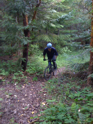
Dan tearing it up that last section up to the Findley Ridge.

The 3 of us took the same ride I took a few rides back- The Findley Peak Loop.  On the way up to the ridge on that loop there is a fairly steep section.  Due to the tank trap about 200 yards back there is very little travel on this section.  Lots of deep madrone leaf litter.


From there, we headed south just below the Findley peak and headed down until we hit the Layton Ditch Mine Trail.


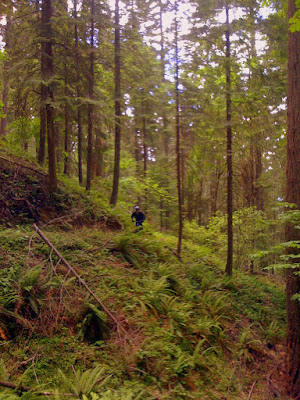
On the way some very nice vistas of the valley.


One the trail it was very technical in places.  It is a flat run, but very interesting.  Lots of dips into the ditch and back out to the top where you have about 10-12 inches of room to stay balanced on.  There are a few sections where you need to walk over logs and down trees.  Here is what one section looks like.


There are some very nice old growth sections as well as the Manzanita sections as shown above.  There is even a nice section of a Ponderosa Pine forest that transitions into the large old growth sections of Douglas Fir.  After we came out on the top of Panther Gulch there is another trail Mike showed us that keeps you off of the washboard and loose gravel of the Panther Gulch main road.  A nice old jeep trail/ skid road that was a lot of fun.  Thanks Mike for the new trails!


Tuesday, December 13, 2011

Up to Findley Ridge

A fairly standard ride tonight- up to Findley Ridge and back.  I was feeling pretty strong but I only manged to get up to the ridge in 32 minutes from the bottom.  If I rode a little more I really think that I would be able to challenge the record of 30 minutes.  My "sweet" new brakes are giving my annoying squeaks!  Very high pitched.  Maybe they need to be broken in a bit more. 

Sunday, December 11, 2011

Got to ride!

After a busy weekend I had enough time to get out on the bike- just for a bit.  I got pretty lucky with my hydraulic brake issues.  Basically they wouldn't bleed out and the were consistently rubbing on my rear rotor.  The shop called the company and they decided to warranty them.  I got a brand new pair of Avid X7 brakes with carbon levers.  They are nice!  Just rode part way up findley and back.  About a 35 minute round trip- enough time to try out my sweet new brakes!

Wednesday, December 7, 2011

Findley Peak Loop

I explored a new route today up on the top of findley.  It was an area that I have been up before to connect with panther gulch.  We had noticed an old trail heading towards findley peak and always wanted to check it out. I have the map posted below.


I snapped a few photos up on the ridge and on the peak.

This one is looking towards panther gulch.  Over this mound and you will hook up with a motocross trail that will connect with panther gulch road.

Looking on the trail- not well traveled.


looking to the north from findley.


I'll have to record the time and mileage next time.  I forgot to record it.


Wednesday, November 30, 2011

Findley Peak at Sunset

This afternoon I was able to get out on the bike in time to make the sunset up at the peak.  Great weather!  Lots of sunshine but a little on the cool side.  I was short sleeves and leg warmers all the way to the top.  Once I was at the top it was definitely time for the jacket.  I was able to get up to the first ridge in 33 minutes.  I pretty good time considering the condition of the road.  For the entire ride, I was able to make it without putting my foot down and stopping.  A good accomplishment for me as the road was very slippery.  The most difficult section is actually the last push up to the peak.  Once I got up there, it was probably about 10 minutes till sunset so I snapped a few pics.


I thought this pic was cool, with the sun in the background.

Going
Going...


 Gone!

A great ride other than my rear brake has been giving me fits.  It has been rubbing on the rear rotor and now the lever is way too soft.  I think there is air in the line.  It's to the shop as it is beyond my mechanical capabilities.  I hope I can have it back by the weekend.  I think the weather will still be nice for riding.

Friday, November 25, 2011

Ferris Gulch to Findley downhill

Its been raining off and on again.  We were lucky enough today to have another break in the weather.  We had a crew of 3 today.  Ian hooked up with Dan and I to go for what we had planned to be a fairly quick ride.  It is right at 15 miles round trip.  Headed out about 2:15 on Williams Hwy towards the Junction of Hwy 238.  Headed east on highway 238 towards Ferris Gulch Road.  We hit the climb pretty hard to the top where the rock pit is and snapped a few photos.
Happy to be here!

Lets get serious now.

Ian brought his Contour 1080p helmet cam- pretty sweet!  Here is some initial footage of the downhill where Dan had a "not so good" day. I guess a bad day mountain biking is still better than a good day at work- most of the time anyway.  Dan had a pretty serious crash towards the end, luckily no broken bones.  We will see how he feels tomorrow after this one.

The middle section of Findley has some very slippery sections now.  Someone actually tried to drive up the road and the road is really ripped up now.  There was a nice coating of mud on the bikes so we had to give them a bath...


Wednesday, November 23, 2011

A break in the weather?

It has been raining pretty heavily off and on over the past few days.  I noticed this morning that there was a break in the rain and it had really warmed up.  I had the chance to get out on the bike so I took it!  Amazingly enough, it was shorts and T-shirt weather.  I knew that the weather could change at a moments notice so I packed my jacket and my leg warmers just in case.  As I was heading towards Findley Road I noticed towards Greyback mountain that there was a heavy storm coming.  Is there a chance that it would miss me?  The wind was blowing towards me, moving the storm closer to my direction.  I hit the bottom of Findley and started the climb.  I knew that if it did start sprinkling I still wouldn't need the jacket since the Findley climb will surely warm me up.  Well it wasn't too long into the ride until the rain started to come as well as a drop in temperature.  I was fairly close to the first ridge top when I decided to put on the jacket.  I climbed in a decent time regardless of the extra muddy conditions.  After the first ridge, I decided to head to the peak, it wasn't raining that hard and I was prepared in case it really started coming down.  It continued to cool so once I reached a fairly flat portion of the road I put on my leg warmers.  I climbed to the top of the peak.  It is pretty muddy so it was an extreme challenge to make it without stopping.  I made it most of the way and had to walk a short portion.  It wasn't raining that hard and got a nice vista of the valley.

I didn't stay long at the top because I knew I would start getting cold.  I did take enough time to text this pic to my riding buddy who is at work today.  Brutal, I know.  Great downhill with mud flying everywhere.  The bike and I needed a serious bath.  I am hoping to get out again- looks like the weather is going to clear up.

Sunday, November 20, 2011

Panther Gulch to East Fork Loop

We took off about 2:00 this afternoon and enjoyed some beautiful weather.  It was a little cool but the sun was shining.  We headed up to panther gulch via Williams Hwy.  We decided to head up to the upper road that traverses the ridge south up Panther Gulch.  We noticed several hikers parked at the Layton Ditch Mine trail.  I took a few photos off the Jeep road looking west to the beautiful Williams valley.  It was a 19 mile trip, 1hr 45 minutes.  There are quite a few road miles and it definitely got a little cool on the way back.  I have noticed that Mountain miles you never get very cold.


Nice view of the valley!

A look at the "Jeep" road back up the hill.

Saturday, November 12, 2011

Not riding enough...

I headed out solo towards the Findley ridge top about noon today.  Surprising weather.  Sunny and fairly "warm"- relatively speaking.  I was dressed with shorts and a short sleeve under armor under my riding jersey.  I knew that it was way too warm to have the jacket on up Findley.  I packed it in my backpack because I knew it would be cold on the way down.  I was straining to keep a decent pace up.  I pushing it pretty hard- at least to my limit at this point in my fitness level.  Took me 33 minutes to get the top of the ridge.  I really haven't been riding enough to challenge my ultimate goal of a sub-30 minute time up Findley ridge.  It will be tough to get more rides this time of year due to weather and daylight.

Sunday, November 6, 2011

A new ride- Upper East fork ridge

Today I headed out excited to try a new route.  The temperatures have dropped significantly.  I had to dress accordingly- I decided it was time to try out my new Novara Thermal Tech Leg warmers.  We decided to drive up to a fairly central location on the route- note the location at the bottom of the post.  We headed south on east fork until you hit the second gate.  We headed up a few miles on East Fork.  There is a gate that essentially marks the official end of east fork.  From there you can continue south on east fork until a turn out and the road turns to a single track.  You have to cross a creek which I believe is Pipe Fork.  There is another yellow gate that seems to be in the middle of nowhere.   There is a fairly obscure trail that you head east on.  This will connect you with a system of old logging roads on what I would call upper east fork.  I can't tell you exactly the route we took.  The map below highlights the approximate portion of the route that we took.  There was  some great single-track and some great views from the ridge top.  Not a lot of miles but a lot of fun.  Thanks Mike.

Sunday, October 30, 2011

Findley Ridge

Headed out about 5:30 tonight solo anticipating darkness soon.  I packed the jacket this time- last time it was way too hot to wear it on the way up findley.  I haven't been riding enough to break the 30 minute boundary from the junction of Findley/ Williams Hwy.  Made it up in 30 minutes tonight.  I had the Serfas 500 lumens on my helmet for the way down.  I only needed it in a few spots where there is canopy cover.  It was still a little light by the time I made it back to the house.  These evening rides are going to be very dark especially when the clocks roll back next weekend.

Monday, October 24, 2011

Findley Ridge Dusk Ride

Headed out this evening solo at about 5:50.  The forecast for tonight is a pretty hard freeze.  As soon as the sun was behind the mountain it was getting cold.  I am thankful that I had picked up my Novara Jacket about a month ago at REI.   I was a little warm on the way up (when am I not warm up Findley).  Perfect on the way down.  The Jacket is supposed to be windproof at 60 mph. 

I had a pretty good time to the top of the ridge- 31 minutes from the start the junction of Williams Hwy/ Findley Road.  By the time I reached the ridge it was starting to get dark.  I turned on the lights and headed down.  I might have to move my light from my helmet to the handlebar.  On these cooler nights there is quite a bit of moisture in the air.  In a few sections it was difficult to see as the light reflected off the fog.  I also have decided I need to upgrade my cheapo safety glasses for some real night eye wear.

Friday, October 21, 2011

Findley Peak Night Ride

Headed out about 6:15 tonight, it has been getting dark by 7:00 now.  We knew that we would spend a lot of the ride in the dark tonight.  It has been great weather lately.   It does get pretty cold as soon as the sunsets.  We both had the riding jackets on.  On the way up they were pretty warm but on the way down it was nice to zip them up and try to stay warm.  I wasn't paying attention to the time on the way up.  Round trip was 1hr 19 minutes.  We were pretty slow on the downhill.  The battery on my helmet light died- shouldn't have tried to go on 2 rides without charging...  Both our handlebar lights seemed that the battery life was a little low as well.  They are only 220 lumen.  Time to get that 1000 lumen light!  I've been thinking about Applegate lake trails again.  Would be great to get up there again and climb stein butte again.


Saturday, October 15, 2011

Findley Peak

Headed out this evening about 5:15 toward the top of the "Findley Peak".  Check out the location on the map.  There is a great view up there of the Williams Valley.  I made it to the top of the ridge in 31.2 minutes.  Not a bad time, considering I have really only been riding once a week.  My last ride was pretty intense and lengthy- honestly it took me a few days to recover from it.  I reached the top of the Peak at 46 minutes.  It gets pretty steep the last section to the top.  The sun had set, there were high scattered clouds that reflected the afterglow.  It is getting dark early now.  I turned on the lights and headed down.  I really only needed it in a few of the heavy canopy areas.  By the time I reached the highway it was light enough to ride without the light but nice to have it.  10.3 miles round trip and took 1hour 9 minutes back to the house.  Not a lot of miles but high intensity ride.

Saturday, October 8, 2011

42 Miler

Dan recently celebrated a birthday and today he finally got to open his present- A 42 mile ride with a whole lot of vertical.
Happy Birthday Dan!

We parked at the top of East fork road and rode the old trail that connects with Thompson Creek Road.  From there we headed down to Applegate Lake.  There is about 1200 vertical to get to the top of Thompson creek road from where we parked the truck.  The road to applegate lake from the top of Thompson creek is traveled frequently by cars- we only saw 2 on the way over.


On the way to the Lake- Carberry Creek

Now once we got there it was time to begin the fun.  It only took 1hr to get to the lake from where we parked the truck. Stein Butte was our goal, ride to the top of that and then head back.  I got the idea from a map I picked up at a local bike shop.  Treadmaps.  Pretty nice map and a lot of information.  I purchased the Southern oregon map.  A few specs on the trail from treadmaps include a Elevation Gain/Loss of 2110ft and a Ascent Total of 3786 feet.  4.9 miles total.  After a few miles up we could tell that this trail was going to be a tough one.  It seemed to go on and on.  It is a really nice singletrack with some very steep sections.
Dan ripping up the Butte.

Once we got to the first ridge top it was quite a view- what we like to call a "double rainbow" experience.
Looking north towards Applegate Lake

At this point it was easy to tell that it was going to be along ride.  We left the truck at 3:30.  It took an hour to get to the lake and we were about 2.5 hours total trip time to this point.  We had a few more miles to go before the turnaround point.  It was going to be getting dark soon.

looking south towards California.  This ride is quite close to the Oregon/ California border

Below you can see some more detail about the Stein Butte Ride

We spent probably about 1.5 hours in very dark conditions.  Good thing 1 of us brought a light.  We also luckily packed our jackets.  The temperature dropped as soon as the sun went behind the mountain.  There was a little cramping on the way back.  There was 1 individual on the ride (not to mention names) who brought 1-21 oz water bottle with Gu Electrolyte brew- its good, but not that good.  Great ride overall.  We climbed a total of 5225 vertical feet.  Right at 5 hours total trip time.  A lot of good memories.  I have realized that the Applegate Lake area really has a lot of good trails to offer. Next time maybe I'll drive over there, maybe not- its always good to get a challenge in.


Saturday, October 1, 2011

Findley and not feeling 100%

I needed to get out on the bike tonight.  It is starting I started coming down with a cold last Sunday afternoon.  I have been feeling a little better.  At least I am feeling well enough to take a quick ride up Findley and back.  Surprisingly I had a decent time to the top of the Ridge- 32 minutes.  I am ready to kick this congestion in my sinuses and get back to some serious riding.  I still am thinking that I can get below 30 minutes to the top of the ridge.  Days are getting shorter now.  Sunset was at 6:57- I headed out about 6:15.  When I got back it was still before twilight.  It is starting to cool down finally- I might have to get out some long sleeves soon. 

Saturday, September 24, 2011

Findley Peak

Nice ride today.  Dan and I rode up to the top of peak 3100ft.  Nearly 2000 vertical feet to the top.  It is only 10 miles round trip.  We took our time, nice and easy to the ridge top, 34 minutes. It took 1 hour 20 minutes to the peak.


What a view up there!


Sunday, September 18, 2011

Findley to Ferris Gulch Ridge

Headed out Sunday afternoon for a solo ride.  There is a pretty fun ridge system on the top of Ferris gulch that Dan and I have ridden before.  I wanted to head up this from the top of Ferris gulch rather than the bottom.  I headed up findley only (32 minutes to the ridge top).  Down into ferris gulch and up to the the main ferris gulch road that is in the large rock pit.  Only 1 mile or so up to the ridge top of Ferris.  To hit the trail you have to look pretty carefully.


Here is a look at the trail once you get started.  The trail follows the ridge system and ties in with a road.

I noticed once I got to the bottom of the road that connects in with the Ferris Gulch main road that someone had blocked off all the motocross trails with boulders. 

Great views from the ridge.
Look carefully and you can see Mt. McLaughlin

All the pictures are geotagged.  Check out all the photos here.

Sunday, September 11, 2011

Better this time

Left the house around 6:45 this evening.  My last post mentioned I was a little disappointed with how long it took me to get the the ridge top.  I was determined to get up there in faster time.  I started the stopwatch at the bottom of the hill.  I also noted that my overall time from the house was 5 minutes 15 seconds.  It was still pretty warm although the sun was down.  I reached the ridge top at 30 minutes 25 seconds/ 35 minutes from my house.  It would take quite a bit more work to get that time below 30 minutes.

Thursday, September 8, 2011

Disappointing ...

Findley road tonight.  It has been really hot lately, 98 to 100 most of the week.  I headed out about 6:45 to the Findley Ridge (not the peak like last time).  Hoping to beat my record of 30 minutes from the bottom of the road to the Ridge.  I'm not sure why I was slower than I thought.  It was warm, but the sun was down.  31 minutes 24 seconds to the ridge top.  There is a haze in the air from some of the fires- probably the one in the little butte creek area.  Next time.  My goal is to get below 30 minutes.

Here is where I stop time, the Ridge top.


Friday, September 2, 2011

The top of the peak!

1hour 10 minutes round trip to the top of the peak up Findley and back.  10.4 miles round trip.  I forgot to check the clock when I got to the top of the peak.  It took 31 minutes to get to the first ridge top that I usually time myself to.  This could be the new Findley ride- I'll call it Findley Peak.  Quite a view up there!  Check it out:


A few other pics from the ride.

Monday, August 29, 2011

Findley Night Ride

It is starting to get dark earlier now.  I headed out about 8:15 and darkness was falling fast.  I climbed fairly quickly up Findley tonight right at 31 minutes to the top.  Most of the climb was in the dark.  On the way down I saw a black tail sticking up in the air, right on the edge of where my light could reach.  I slowed down to soon realize it was a Skunk.  I went slowly along the road hoping that it would veer off into the brush.  Unfortunately it just walked along the road for probably 3/4 of a mile.  Finally it decided to leave and I was able to get down the mountain.  I think I would like to get a more powerful light to pick up on these critters a little more quickly!

Saturday, August 27, 2011

Findley evening ride

Tonight we wanted to go on a slightly longer ride than just findley and back.  The standard Findley ride is right at 9 miles.  This evening it was 11 miles.  We went up the next ridge, near a logging operation.  There is a great view from up there, there is one more ridge to climb up there to get a panoramic view.  We stopped at the first saddle.  See the locations on the map.  We were able to talk as we climbed --we weren't going 100%.  We still made good time to the top.  I forgot to reset the timer so I don't have an exact time for the ride.  It was about 1hr 15 minutes.  Most of the time on the climb the % grade was hovering around 12 to 15 percent.  The total vertical was 1850 ft.

Sunday, August 21, 2011

Panther Gulch Ride to East fork

We headed out about 7:15 p.m. with lights ready.  A fairly warm day today.  It seems that summer has finally decided to show up - still only in the 90's.  When we took off the temperature was very comfortable.  We got up to the yellow gate on panther in about 40 minutes from Dan's house.  A fairly comfortable pace, where we were able to talk as we climbed.  It started to get pretty dark a little after 8 especially in the real shady areas.  It is a nice decent on the old jeep road that connects with the upper part of east fork.  (see the location pin on the map).  Good ride and took about 1 hour 30 minutes.  Next time I think we will leave a little later to enjoy some of the night riding.

Thursday, August 18, 2011

Findley early night ride

Headed out probably 7:45 tonight for the top of Findley Road.  The sun was behind the mountains and it was starting to get dark.  There was enough time to make it to the top of the ridge in the light.  I looked at my timer, it read 5:02 at the bottom of Findley road.  At the top, the timer was 35:32.  Basically, 35 minutes from the house (30 minutes from the bottom of the road to the top of the ridge) which I believe is my best time.  I still haven't made it less than 35 minutes from the house.  When I made it back to the house- 52 minutes round trip.

Monday, August 15, 2011

Findley to Ferris Gulch to Panther Gulch to East fork rd

It has been a while since I've done this ride, I didn't remember when it was- I looked back and it was about a year ago- 8/20/2010.  It took me 2 hours and 8 minutes back then.  Left the house at 4:30 and it was still a little warm.  A fair majority of the route had shade.  Took 36 minutes to get to the top of Findley Road from the house.  Along the ridge to the top of panther gulch I kept it in the 2nd chainring most of the time and cranked away.  It was 19 miles and took 1 hour 46 minutes round trip- I guess I am in better shape than last year.  Also a year ago I was riding a much different bike.

Friday, August 12, 2011

Findley Night Ride

I've been wanting to try a night ride for quite some time.  I think I found a pretty good light system for a very resonable price.  It started with a cheap zefal combo headlight/ taillight.  I then saw a nice flashlight that boasts 220 lumens - and it fits in the zefal mount.  I'm not sure what the zefal light puts out but it is not for riding off of the paved bike path.  All for about 37$ with amazon prime!  It was time to ride so I thought why not my "favorite" ride.  I headed out about 8:20 pm and knew it would be dark soon- sunset is 8:15 now.  The moon was very nearly full.  I took a picture with the old iphone which didn't turn out that well.  It was quite a scene looking towards Ferris Gulch as the moon was rising.


It really added a new dimension to the ride that I have done a lot.  It was a solo ride so I was a little nervous a few times.  With my light system I hit 25 mph on the downhill- much slower than the 34 mph in the day time.  It felt pretty fast anyway...  A lot of fun and I look forward to more rides as Fall is soon approaching.


Sunday, August 7, 2011

Pipe fork and Glade fork - a new ride.

Thanks to our local community list serve I met another mountain bike rider.  He had an excellent suggestion to go on a ride that is off of Rock Creek.  Below is a map of part of the route we took.

We went up Rock Creek across Glade fork to the Pipe fork.  The climb was about 2000 vertical until we headed down a great single track.  We unfortunately ran into a new logging operation where part of the old road was redone- I guess it was a pretty nice section to ride before.  There was, at times about 6 inches of dirt powder because gravel hadn't been added yet.  The bikes needed a bath after this ride.  We didn't head up the ridge towards Thompson creek as time was running short.  Just headed down the upper east fork road.  Again the location says Cave Junction which is wrong, it should say Williams.  I dropped the pin on the Rock Creek Road that we took that connects with the single track trail.  Overall, a great ride!  Next time a few pics...

Friday, July 29, 2011

The ride formerly known as "The Grind"

I'm not sure what to call this ride any more, we used to call it "The Grind".  It is a pretty decent climb but I think Findley probably should be called "The Grind"- especially when the Findley Double is taken on.  It took me 17 minutes to get up to the intersection of Panther Gulch and East Fork.  After that it was 34 minutes to get to the gated road that traverses the mountain towards the old jeep trail that connects up with East Fork again.  I left the house around 8:00.  It is a little late to be leaving that late for this ride.  It took 1hr 19minutes round trip.  Unfortunately I don't have a light so it wasn't real safe on the way back- I'll have to pick one up in-case this happens again.  19 miles total.

Wednesday, July 27, 2011

Findley Evening Ride Again

After my last quick ride up findley I really appreciated how cool it was.  It just worked out for me to head out again for an evening ride.  This time close to about 8:15 I left the house. (getting pretty dark by the time I get home)  I got up to the top in 34 minutes from my house.  I notice it takes me about 4 minutes to get to the bottom of findley,  I ususally don't time myself from the bottom of the road but I'll start making note of how long it takes me to get there.  So, from the bottom of Findley it was 30 minutes 14 seconds to the top (basically where the junction is posted below)

In this photo you can't see the intersection but this is where I record the time as "the top".

Monday, July 25, 2011

The Right Time for Findley

Tonight I headed out about 8:00 p.m. for the top of findley.  There was plenty of light when I left.  The sun was starting to set.  It was much cooler than the last time that I did this ride.  The heat really slowed me down.  I was 2 minutes faster- 35 minutes to the top from my house.  My legs did not feel 100% even though I had a day to rest from our intense Grayback Mountain trip.  Tonight was nice and cool a great time to ride!  I was a little dark in some of the areas that have a lot of canopy cover.  Makes me really consider getting a light and doing some night rides.  I'd have to get some clear lenses though....

Saturday, July 23, 2011

Grayback Mountain Trail #2

We headed out about 11:30, thinking that we would climb to the summitt of Grayback Mountain- 7048ft.  Honestly, the climb was a little more than we had anticipated.  Much of the trail is pretty rough on a bike- lots of debris, fallen logs and fairly large rocks.  On the upper portion of the trail we found ourselves getting off the bike quite frequently.  About 4 miles into the ride Dan got a flat tire.  I always carry a tube for my bike- a 29er.  His bike is not a 29er.  We thought what is there to loose?  We put my 29er tube into his 26 inch tire.  It held up most of the trip.  I was quite surprised that it actually worked.

There were 2 areas on the trail that were a little difficult to follow.  One point on the top of the first ridge portion of the trail, we actually missed the trail.  One more time, part of the trail follows what appears to be an old skid road used for logging.  Keep a close eye on a switch back- we missed it.  We followed a skid road until the trail luckily crossed paths with it.  A few portions of the that skid road were quite rough and very steep. 

The elevation was effecting my ability to recover on some of the steep climbs and switchbacks.  It was a very tough climb.  Bottom line the tanks ran out of gas.  We didn't bring enough water or food.  We got to a point that was quite close to the top- I think about 1/2 mile or so.  We headed back down the trail.  We made it about 4 miles from the truck when Dan's tire gave out.  Most likely a pinch flat with the 29 inch tube in the 26 inch tire.  I filmed the downhill with my flip cam- unfortunately it wasn't quite pointed on the trail.  I have some footage of the climb up and a stop we made with a great vista. 

Next time we will be a little more prepared and reach the top- a great ride and 4 hours of mostly fun.  (minus the flats and the down logs on the trail.) Location says cave junction- not sure why- it is in Williams.  The location is actually where we turned around...

Friday, July 22, 2011

Findley Road with a video camera

I had what I thought was a brilliant idea.  Zip tie my flip cam tripod to my helmet and film my ride.  It felt pretty heavy actually.  It is weird how a few ounces make a difference.  I noticed that the position was off a little- it would have been better if the camera was pointed up a little more.  Another hot ride- I took off about 11:30.  I filmed the way up- not too exciting.  I got to the top in 37 minutes.  At least I am starting to feel somewhat conditioned to ride in the hot weather.  Here is the trip down findley.  Top speed 33 mph.

Wednesday, July 20, 2011

Findley Road

Nothing too exciting, a nice ride up Findley Road and back down.  It just rained pretty heavy recently.  The road wasn't too dusty.  I headed out when it was pretty hot, about 3:30 probably.  There are several portions of the road with a lot of exposure in the afternoon.  I felt close to being "overheated" by the time I got back.  Made it to the top in about 37 minutes.  Wasn't too bad considering it was pretty hot.

Wednesday, July 13, 2011

Findley to Ferris Gulch

The last time I did this ride, I remember I was freezing! Here is the link to that post...  Findley is normally not a good ride in the afternoon due to the exposure.  Lately it has been cool for this time of year so I decided to head up the mountain.  I also wanted to get a few more miles in that I have been lately.  I rode up Findley, down into ferris gulch, back out to the ferris gulch road to Hwy 238 and then took that back to my house.  It was 1 hour 15 minutes and 14 miles.  It was a little windy on the road- I was pushing it pretty hard.

Tuesday, July 12, 2011

Grayback Mountain Trail

We jumped in the truck and headed up to the Grayback Mountain trailhead up rock creek road.

This first photo is a a shot from the upper trail head access- as you first enter the trail.

From 2011-07-12 Grayback Mountain Trail
These second two photos are from the lower part of the trail- there is still is some debris that you need to climb over on the trail.

From 2011-07-12 Grayback Mountain Trail
We ran into a fuel reduction project.  There was a lot of down brush on the trail for about 150 yards.  We had to wade through limbs and down trees- not much fun at all.  We had to carry our bikes the entire way.  I'm hoping all the down brush will be off the trail and in piles real soon.  I was thinking, I hope they don't make a pile in the middle of the trail.

Sunday, July 10, 2011

The Findley Double

Tonight our family was heading over to a friends house who lives over on Panther Gulch.  So I thought why not ride over there?  I definitely wasn't going to take the direct route.  Up Findley Road to the top of the ridge and then hook directly into Panther Gulch.  I haven't been on my bike a lot lately so it was a bit of a struggle to get up the mountain.  I took a few pics on the way up there, some great vistas.  A little under 9 miles to our friends house but it is a grueling 9 miles.  Took about 1hr and 15 minutes to get over to panther gulch.

Tuesday, July 5, 2011

Grayback Mountain Trail

Today we took the truck up Rock Creek Road with our bikes. It is nice to hop on the bike from the house but we needed to get to the fun stuff.  We parked about a mile up Rock Creek and started the climb. 

You can drive to the bottom of the trail head, we took the road to a junction on a gated spur road and started heading up towards Grayback.  Essentially we wanted to do at least a portion of this trail posted here on this blog post. (scroll down a bit).
 
Getting ready to head up the trail.


After accessing the upper part of the trail we headed up the mountain towards the summit of Grayback.


The upper trail access, you can head up to Grayback or down.

The upper trail had a lot of loose leaf litter on it, tan oak and other leaves.  It looks like some horses had recently made their way up because it seemed almost tilled in places.

A great ride for a warm day, lots of canopy cover.


There were a lot of neat rock outcroppings throughout the trail.
This one dropped off about 25 feet.
The trail for most of the way was a fairly gradual climb and actually quite technical in places.
Pretty easy section here.


We turned around once we got a nice vista of the top, next time we are going to take it to the top.  We rode only about 8 miles round trip and traveled close to 1500 vertical in that distance to where we turned around.  Probably the best trail around Williams.


Here is the top of Grayback.

On the way back down the trail.